ABQ finds widespread heat discrepancies between communities
December 6, 2021 - Rebecca Hobart
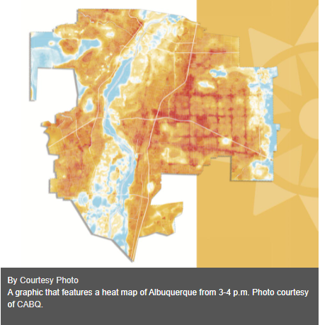
The city of Albuquerque released its heat map findings from its heat watch report in late November, compiled by Climate Adaptation Planning Analytics Strategies, a contractor of the National Oceanic Atmospheric Administration. The study looked at heat impacts on human health through temperature and humidity data points collected on July 9, 2021.
Kelsey Rader, the city of Albuquerque's sustainability officer, said this report was an opportunity to evaluate how existing infrastructure was supporting active and public transportation users.
The study produced results showing a temperature difference of nearly 17 F from the hottest to coolest parts of the city. Rader said this is a call to action to manage this discrepancy through tree plantings, which has a dedicated budget with the city.
The defined study area sought to illustrate current conditions during the hottest month of the year — July — to inform future decisions on tree planting and other urban heat reduction strategies. Rader said this data and knowing possible solutions exist could serve as a call to action and bolster Mayor Tim Keller’s goal of planting 100,000 trees in the next 10 years.
“It’s important to understand that we are not experiencing isolated incidents of heat. We’re locked into a trajectory where we are going to be experiencing longer summers, higher heat waves,” Rader said. “This is already a dangerous problem that is going to continue to accelerate over time.”
Claudia Isaac, distinguished professor of community and regional planning at the University of New Mexico, said the report illustrates areas as characteristically hot, like the corridors around the Interstate Highways 40 and 25. This is also seen in some low-income neighborhoods near there, such as the International District, which is notably tree-scarce. She said these areas tend not to be “as well-resourced.”
“Poor areas tend to be un-treed, partly because people are working two to three part-time, variable hour jobs and … don't have time to go to their city council or call the sustainability office and say, ‘We want trees,’” Isaac said.
Rader said the defined study area intentionally focused on parts of the city with active transportation routes.
“With our public transit users, we know those are predominantly low-income folks,” Rader said. “Active transit users, of course, are also going to be more at risk of suffering from heat stroke or other heat-related, health-related impacts.”

Populations dependent on public transit are often in high traffic, urban communities, such as those along Central Avenue, and often lack sufficient green infrastructure, according to Isaac. She said high traffic roads in areas, such as the West side, show greater temperatures in the city’s report.
“Finding funding for increased public transit, which is critical in poverty-reduction because that’s how people get to work, also reduces car use,” Isaac said.
In the morning from 6-7 a.m., Rader said the temperatures were as high as 79 F in downtown Albuquerque and the intersection between I-40 and I-25. She said the lowest temperatures in that morning hour were around 62 F around the Sandia foothills.
Rader said 90-103 F is the common heat range for Albuquerque during the summer, which is classified by NOAA as an “extreme caution type of heat.” Consequential effects from prolonged exposure to extreme heat conditions could be heat stroke, exhaustion and cramps, according to Rader.
The afternoon temperatures, measured from 3-4 p.m., also produced temperature discrepancies between the coolest and hottest parts of the city, according to Rader, with values of 94 F and 105 F. She said these areas may be lacking in adequate tree canopy and shade structures.
“This data is really useful in seeing how the (existing) infrastructure affects heat absorption,” Isaac said. “Paved roads, especially paved roads with a lot of traffic on them, absorb and then radiate heat. It’s not surprising that downtown and parts of the west side, particularly during the afternoon rush hour, are hotter.”
Rader said asphalt is the predominant concern with addressing morning temperatures, since shading infrastructure wouldn’t help with the indirect sunlight. Asphalt produces higher temperatures due to absorption of heat and its continued release of that energy through the night. Rader said the city plans to continue implementing solar shade structures in city facilities to offset heat in areas with large amounts of asphalt.
“That really highlights to us that there are solutions here,” Rader said. “If there are parts of the city that are experiencing these lower temperatures, of almost a 17 F difference, that means that tree cover, tree canopy, shade structures can make a huge difference in addressing some of the areas of our city that are experiencing some of the highest levels of heat.”
Rader said the “Let’s Plant Albuquerque” initiative has developed a “climate ready tree list” for Albuquerque. She said the initiative anticipates climate variability from year to year and will inform the city on what types of trees would perform best to address the city's goal to mitigate temperature discrepancies.
“They’ve selected trees that are going to be non-water-intensive, prepared for some of the anticipated impacts of climate change in Albuquerque, such as rising temperatures and less available surface water,” Rader said. “It’s a fine balance — finding appropriate trees to plant in this region that are going to survive knowing that we’re going to have variability in our surface water resources for years to come and, of course, overall rising temperatures.”
Rebecca Hobart is a senior reporter at the Daily Lobo. She can be contacted at news@dailylobo.com or on Twitter @rjhobart
Read Daily Lobo article here.
